Hidden Histories: Declassified Satellite Images Reveal the 1,400-Year-Old Battlefield of Al-Qadisiyyah
In an extraordinary confluence of modern technology and ancient history, declassified spy satellite images have led to the discovery of the long-lost site of the Battle of al-Qadisiyyah, a pivotal moment in the Muslim conquest of Persia. The discovery, detailed in the journal Antiquity, reveals how U.S. Cold War-era surveillance unintentionally preserved clues to a battlefield that shaped the course of Islamic history.
A Window into the Past
The story begins with satellite imagery captured in 1973 by the KH-9 "Hexagon" reconnaissance program, a cutting-edge spy tool of its time. The KH-9, often referred to as "Big Bird," was part of an advanced U.S. system designed to monitor geopolitical developments during the Cold War. Decades later, these images, declassified in 2011, became a treasure trove for archaeologists looking to explore ancient landscapes.
A team led by William Deadman, an archaeologist at Durham University, stumbled upon the battlefield while analyzing these images. Their primary focus was the Darb Zubaydah, a historic Hajj pilgrimage route stretching from Kufa in Iraq to Mecca in Saudi Arabia. The route, prominent during the Abbasid Caliphate (A.D. 750–850), was under review for potential UNESCO World Heritage Site designation. However, the high-resolution imagery unveiled something even more remarkable—a site that matched the historical records of the Battle of al-Qadisiyyah.
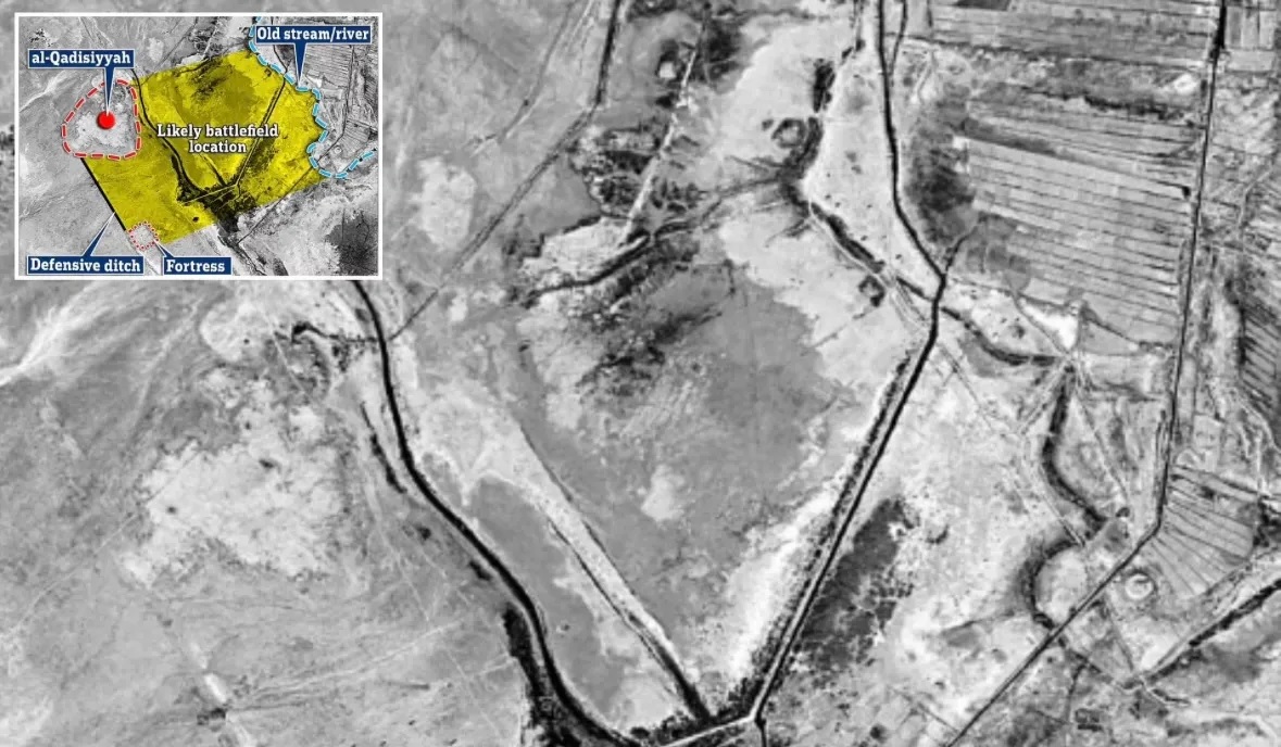
The Historical Context
The Battle of al-Qadisiyyah, fought in A.D. 636 or 637, was a decisive confrontation between the Arab Muslim forces and the Sasanian Empire, which then dominated the region of present-day Iran. The battle not only marked the fall of Sasanian power but also set the stage for the rapid spread of Islam across Persia and Central Asia. According to historical accounts, the battlefield was characterized by a 6-mile-long wall, a moat, and its proximity to a body of water and a bridged stream.
Pinpointing the Site
Using the declassified KH-9 images, the research team identified a modern agricultural field in Iraq that corresponded with these descriptions. Ground surveys further confirmed the presence of the 6-mile-long wall and the moat referenced in historical texts. The precise location had remained elusive for centuries, but this combination of satellite imagery and archaeological expertise provided a breakthrough.
"This discovery provides a tangible geographical context to one of the founding stories of Islamic history," Deadman remarked. The battlefield is more than just a historical site—it is a symbol of cultural transformation and the expansion of Islam into Iraq, Iran, and beyond.
From Surveillance to Scholarship
The rediscovery of the Battle of al-Qadisiyyah underscores the unexpected ways in which Cold War technology has been repurposed for academic and cultural advancements. The KH-9 imagery, originally intended for espionage, is now helping scholars reconstruct lost landscapes and unearth forgotten chapters of human history.
This find also highlights the evolving role of satellite archaeology, which combines historical research with state-of-the-art technology to solve mysteries that traditional methods cannot. From identifying ancient pilgrimage routes to pinpointing battlefields, the possibilities are vast and transformative.
As the story of al-Qadisiyyah emerges from the shadows of history, it serves as a reminder of how past events, no matter how distant, continue to shape the cultural and political landscapes of today.


